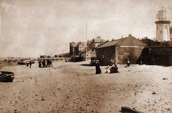
Here’s another really old photo of North Parade, dated from c1898 and kindly sent in by Syd Bird. No sign of a promenade wall, or promenade at all for that matter in the foreground. Look in the background and you’ll notice some construction work of an in-progress promenade. Click on the photo for a larger view and you’ll see the old, old lifeboat station. Syd tells me that the sign on the timber gates says “Horses Kept At Jesse Bird`s Market Street” – for more images of 80 Market Street go here. So much local history in this photo if you look for it.

Well, I am now confused about the chronology of this photo and the recent Friday photo of ‘Marine Parade’.
The earlier photo showed a seawall which I believe is not the promenade wall (as it is set too far back) and is not visible in this photo.
However, perhaps the structure on the beach is not the North Parade under construction but some sort of earlier hard standing perhaps used by local fishermen? If you look closely at the Marine Parade photo there appears to be some sort of structure in the same position. Maybe it is an earlier defensive wall to protect the houses between Trinity and Government Road?
Moreover, there is no sign of construction activity on the ‘promenade’ – ladies are strolling with parasols and donkey rides are in full swing on the sands
All very fascinating! Can Syd cast any light on this?
Hi Peter,
I think it`s always difficult to date these old photos accurately but with this one due to the houses already constructed it must have been taken after 1889 as that date appears on the side of the large house at the bottom end of Trinity Road. According to the the info on the commemorative stone built into the promenade it indicates this was constructed during 1897 and 1898 so I guess the photo must have been taken sometime around then.
Incidentally I have another photo which I believe was taken at the same time but from the location where part of the new promenade seems to have been completed,perhaps it was constructed in separate stages?. In this other photo (which is also looking towards Trinity Road) the promenade looks as though it was only very recently completed as although there are a few seats in place,there are no railings.The only photo of the prom I have come across without railings in place.
With regards to the low sea wall which was featured in another recent photo I have read the following “when building operations commenced in Kings Gap,Lord Stanley erected a sea wall of stone extending to where the Alderley Road shelter now is. On the construction of the present promenade the wall was absorbed and disappeared”,
We need a time machine to take us back to check it out!
Hi Syd
Yes, I would just love a time machine to take us back to that period when Hoylake was on the cusp – in transition from fishing village to a small town.
I agree, the staged construction of the prom seems quite a likely scenario. I would very much like to see your other photo if John could be good enough to post it on here. The 2 photos we are discussing and your information on Lord Stanley’s wall seem to indicate that the prom was built in stages and confirm that the wall in the Marine Parade photo is not the promenade wall.
I just love these historic images and this one in particular is so wonderfully detailed – Syd obviously has a treasure house at his fingertips! One thing that seems to stand out on this one that has tweaked my curiosity – are those large dunes in the distance (where perhaps Hoyle Road or Deneshey Road are today? They look huge! I always assumed that the topography of the shoreline was rather uniform – this would indicate otherwise… does anyone know?
I think the dunes are where Trinity and Clydesdale roads are, if you remember they do climb away from the shore. i also think the “hump” continues to where Ferndale Road meets Hoyle Road as there is also a climb at the start of Ferndale.
Yup – Ian I think you’re right!
In fact Ian the photo posted today definitely confirms that you’re correct (you have a better eye than me) – obviously Clydesdale Road there. I used to live on Avondale Road in the 70s and 80s, that whole neighbourhood (Ferndale, Avondale and Dovedale) must have been built on top of what must after all have been a quite solid piece of land! It’s not possible to see from the photo’s vantage point but I am guessing that Ferndale post – dates this picture – I always assumed the houses on Ferndale were a little older than that.