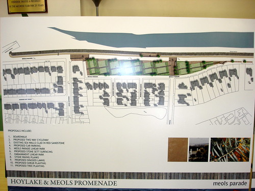
I spent half an hour in Melrose Hall on Tuesday afternoon viewing the presentation of the proposals for the redevelopment of the Hoylake and Meols waterfront. It’s my understanding that the designs are proposals only and a number of development options are being suggested. I also understand that currently there is no funding in place for the proposed redevelopments.
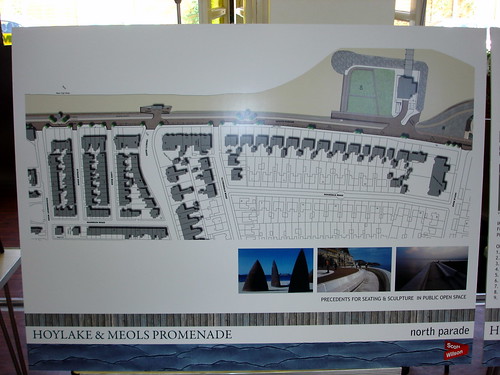
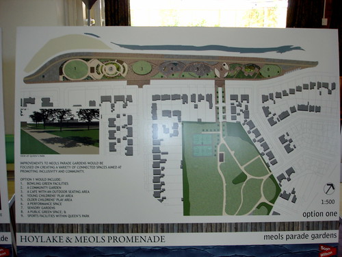
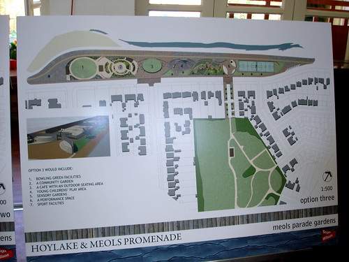
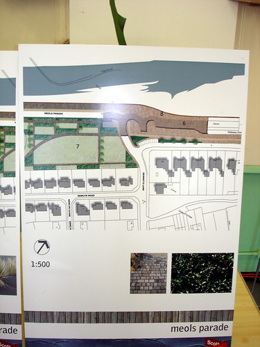
The plans evidently involve a signficant redevelopment of the promenade from Kings Gap to Bennets Lane in Meols. I took some photos of the presented plans (multiple options were presented):
At Kings Gap:

By the new lifeboat station:
This one is option 1:
This one is option 2:

This one is option 3:
At Bennets Lane:
If you click on any of my photos here you’ll link through to some more I’ve loaded in my flickr account.
The council are suggesting a new area named Meols Linear Park I think it was called and this will effectively cover the are either side of Roman Road:
I did ask if there was a council website detailing the proposals – nothing at the moment. There’ll be further public presentations, so I guess I’ll be attending those too now.
What do you think?
Great job in putting these up on site. Thanks!
Plenty of great ideas here. I really like them. Let’s hope some of the local residents aren’t as negative about these as the excellent Market Street improvements and that the Council can raise the cash.
I hope the consultants realise the horticultural limitations of planting things in this neck of the woods. Anyone remember the attempted and completely failed tree planting at Dovepoint after the sewerage pumping station was built in the 70s?
Also did you notice that the model boating lake at Hoyle Slip seems to have disappeared? Is this part of the plan or an oversight?
It’d be good to see Queen’s Park included in the plans too, it’s looking pretty sad but not as bad as the poor old Meols Parade Gardens (once beautifuly kept!). The best thing would be to build a new Hoylake Lido in Queen’s Park, Hoylake isn’t Hoylake without a lido. Talking of Queen’s Park, you asked whether it was in Hoylake or Meols: I always understood that this open space marked the boundary between the two.
Keep up the good work on this site. Very handy for us emigrees!
Hi Peter
Thanks for the comments!
Ah yes, the model boating lake has disappeared – no idea if that’s intentional or not.
All this proposed work will cost a fortune – I wonder where the money will come from?
I’m not sure that Queens Park is the Meols/Hoylake boundary actually. I know that the postal address for Deneshey Road is Meols, whilst Saxon Road is listed as Hoylake.
Well, let’s hope the money is found from somewhere. Investing some money in the sea front for the first time in a century is not an unreasonable expectation! Or rather it should not be!
The Hoylake boundary is definately a little fuzzy but it’s certainly somewhere between Bertram Drive and Deneshey Road. Deneshey is definately Hoylake and I’ve seen Carlton Terrace cited as the boundary but which end marks the boundary I don’t know. The council’s boundary sign used to be by the telephone exchange in the 70s.
If you look at old maps in the early 1900s, Meols and Hoylake both developed towards each other with the last few dunes in between now being the site of the park.
Just a thought; I lived in Saxon Road from 1975-1982 and during that period, the road-sign was ‘Saxon Road, Great Meols’. Can anyone shed any light on this?
Hi Richard
Well I always thought that Deneshey was the last road in Meols and Saxon was (is) in Hoylake.
The road sign for Saxon Road must have been replaced since you moved – there’s no mention of Great Meols on the sign today.
Suppose there’s a boundary map in the library or somewhere – must attempt to find out one day!
Cheers
John
Yes, I remember the Gt Meols sign on Saxon Road too. Although it didn’t agree with the Council’s boundary signs on Birkenhead Road which were by the telephone exchange!
Would be interesting to discover the real boundary line altho’ I’m not sure there is a definitive one. When I was young in the ’60s Hoylake was generally taken to include Gt Meols(often referred to as the ‘Meols end’ as in “I’m just going up the Meols end to see Fred”).
I think the fuzziness is to do with the fact that Hoylake is a relatively recent construct and incorporated 3 existing settlements – Little Meols (the Meols Drive end of town and hence the name Meols Drive), Hoose (the old village area in central Hoylake) and Great Meols. Some of the older maps I’ve seen refer to the King’s Gap / Stanley Road area (centred on the Royal and Green Lodge hotels) as Hoylake and include the other 3 settlement names too. Generally Little Meols seems to have lost its identity fo Hoylake first, then Hoose with only Gt Meols retaining a separate identity albeit more often as Meols without the prefix.
In the early 70s (??) the Council first put up boundary signs and the Hoylake sign was placed on the Meols Stretch. Some Meols residents complained and it was replaced with a Meols sign with a Hoylake boundary sign outside Queen’s Park by the telephone exchange.
I have a map of 1909 which shows Hoylake and Meols growing towards each other:
Hoylake: from the Hoylake end there is continuous development along both sides of Birkenhead Road reaching to Sandringham Avenue and on the south side just a very small field (now a petrol station) between it and Carlton Terrace. On the north side there is a big gap from Sandringham Avenue until the now Hoylake Vetinerary Centre. Hoyle Road is there but is undeveloped sand dunes once away from Birkenhead Road except for The Parade School (now Community Centre) and the house opposite. Deneshey Road is there too but completely undeveloped. The dunes cover a substantial area stretching from Clydesdale Road through The Dale house & estate, what is now Queen’s Park and the old Sandhey house and estate [sadly built over between (?) the wars] and beyond to Dove Point.
Meols: the development of Meols towards Hoylake is linear following B’head Rd to the end of Carlton Terrace on the south side where the single narrow field (now the petrol station) is the only break in roadside development but extensive fields stretch down to the railway and all the way along to Meols Bridge. On the north side of Birkenhead Rd, development towards Hoylake gets as far as the Hoylake Vetinerary Centre (with no RC church) and then dunes stretching to the promenade gardens.
So Deneshey Road was an organic extension of ‘Hoylake’ rather than of Meols! I have read that Carlton Terrace which is the oldest building in that immediate area marks the official boundary. But which end? If it’s the western end then you might argue that one side of Deneshey is in Hoylake but the other in Meols! If the eastern end then Carlton Lane would mark the boundary and both sides of Deneshey would be in Hoylake which would be more convenient!
Can anyone confirm the boundary?
Incidentally I did read that the Hoylake-West Kirby boundary was moved to its present position at some point with Hoylake having previously extended all the way along Meols Drive to the Lingdale / Riversdale Road area. Anyone know anything about this?
That’s my lunch time diversion, now back to work!!
Hi all sorry for the late entry. I hope this information might be of some use to your problems. I live in Carlton Terrace, there are 8 houses in total but the post code is split into two. Numbers 1-6 carlton terrace are postcoded for meols and what where originally 7&8 are now 50&52 Birkenhead road with a hoylake postcode. So the last house in meols is 6 carlton terrace. Ps i would be greatful to see old photographs of the terrace if any body has some or could point me in the right direction. Thanks in advance.
Hello Tony
Thanks for postcode info …one day we’ll work out where Meols stops and Hoylake starts!
Yes, I’d like to see some old photos of Carlton Terrace too!
Cheers
John
re the question about Great Meols- I can’t add anything very intelligent except to say that in the early 1950’s I attended Great Meols School